The Golden Thread http://www.thegoldenthread.info/phpBB3/ |
|
today's earthquakes http://www.thegoldenthread.info/phpBB3/viewtopic.php?f=46&t=1368 |
Page 1 of 1 |
Author: | Siam [ Thu Jan 14, 2010 5:31 pm ] |
Post subject: | today's earthquakes |
MAP 5.2 2010/01/15 00:06:50 7.154 125.847 41.7 MINDANAO, PHILIPPINES -------------------------------------------------------------------------------- MAP 5.0 2010/01/14 18:46:25 42.380 142.959 56.0 HOKKAIDO, JAPAN REGION MAP 5.3 2010/01/14 16:22:38 -11.966 166.209 57.1 SANTA CRUZ ISLANDS MAP 6.0 2010/01/14 14:03:41 11.517 142.113 32.4 SOUTH OF THE MARIANA ISLANDS MAP 5.2 2010/01/14 08:42:13 -41.108 -83.724 10.0 WEST CHILE RISE |
Author: | Bluebonnet [ Tue Jan 19, 2010 8:15 am ] |
Post subject: | Re: today's earthquakes |
5.8 earthquake shakes Cayman Islands Related Content A 5.8 earthquake shook the Cayman Islands, south of Cuba on Tuesday morning, reports said. On Monday morning, a strong earthquake rocked Guatemala and parts of El Salvador, but no there were no immediate reports of injuries or damage in either country. The U.S. Geological Survey says the quake had a preliminary magnitude of 6.0. The USGS says it hit Monday morning about 60 miles (97 kilometers) southwest of Guatemala City, where it was felt by many residents. There were reports of shaking in the Guatemalan countryside and in El Salvador as well. Civil protection officials in the two countries says so far there are no reports of injuries or damage, but authorities are still checking. http://www.miamiherald.com/854/story/1433247.html |
Author: | recall15 [ Thu Feb 11, 2010 3:09 pm ] |
Post subject: | Re:Honduras Twin Quakes 4.7 6.1 |
But what about a Twin Quake Event, BUT Nor USGS: (1) nor IRIS report it! You see the Cover Up at Work: From Today Honduras Local Newspaper (1): translated: Quote: At least a two quakes of 4.7 and 6.1 on the richter scale and a mirror in the morning rocked Honduras, are reported at least 30 houses damaged in Yoro Department, informed the Permanent Contingency Commission, Copeco. The commissioner of Copeco, Randolfo Funez, said the first tremor of 4.7 was at 11.42 am local time (17.42 GMT) with epicenter in the town of Tela, the department of Atlanta at a depth of 71.4 miles. As reported a replica of 4.9 located in Villanueva, Cortes had a depth of 1.0 km and was recorded at the same times as above. 6.1 The second was at 11.56 am (17.56 GMT) with epicenter near near La Rosa, Morazan, Yoro, and 71.4 km depth according to information provided by the Nicaraguan Institute of Territorial Studies, Inet. (1) http://www.laprensa.hn/Sucesos/Edicione ... as-danadas |
Author: | rutsuyasun [ Thu Feb 11, 2010 10:04 pm ] |
Post subject: | Re: today's earthquakes |
also reported in Xinhua: http://english.people.com.cn/90001/9077 ... 94395.html |
Author: | Genesis [ Fri Feb 19, 2010 7:13 pm ] |
Post subject: | Re: today's earthquakes |
i've been feeling those little tremors again, quite regular, for the last few weeks. more so in the last couple days. so, i went looking at seismos and take a look at what i found. does anyone know....is it normal for most of these to have some activity at the same time, all around 12:00? check it out. even Antarctica has a slight indication. eskimo's with snowmobiles goin thru the mcdonald's drive in for lunch? seriously. except for the lunch crowd...what else could cause multiple readings at the same time? http://aslwww.cr.usgs.gov/Seismic_Data/heli2.shtml |
Author: | recall15 [ Tue Feb 23, 2010 10:02 am ] |
Post subject: | Re: today's earthquakes |
There were two Quakes today on Mexico-Guatemala Region: From IRIS Database: Code: DATE links are into the IRIS WILBER system where you can see seismograms and request datasets. DATE LAT LON MAG DEPTH REGION 23-FEB-2010 15:16:06 16.07 -91.31 5.3 38.1 MEXICO-GUATEMALA BORDER REGION 23-FEB-2010 10:52:14 16.02 -91.21 5.6 7.2 MEXICO-GUATEMALA BORDER REGION http://www.iris.edu/dms/seismon.htm A very active day... |
Author: | recall15 [ Wed Feb 24, 2010 4:07 pm ] |
Post subject: | Re: today's earthquakes |
Is the Whale incident in the Aquarium (1) a Quake Precursor (infrasound waves) in FL? (1) http://www.cfnews13.com/Features/Genera ... id=twitter |
Author: | Mikulus [ Sat Feb 27, 2010 7:56 am ] |
Post subject: | Re: today's earthquakes |
Based off that whale's history, no. |
Author: | recall15 [ Mon Mar 01, 2010 5:44 am ] |
Post subject: | Re: today's earthquakes |
There where armonics between the chile event and some quake activity on CA... and still continue these patterns... (1) Code: MAP 5.6 2010/02/27 07:33:31 -38.007 -73.484 35.7 OFFSHORE BIO-BIO, CHILE MAP 5.4 2010/02/27 07:19:49 -35.811 -72.945 35.0 OFFSHORE MAULE, CHILE MAP 6.0 2010/02/27 07:12:29 -33.807 -71.913 35.0 OFFSHORE VALPARAISO, CHILE MAP 3.5 2010/02/27 07:10:48 36.062 -117.888 0.6 CENTRAL CALIFORNIA MAP 2.9 2010/02/27 07:04:24 40.138 -121.317 8.6 NORTHERN CALIFORNIA MAP 2.9 2010/02/27 06:56:03 36.073 -117.878 2.5 CENTRAL CALIFORNIA MAP 6.2 2010/02/27 06:52:35 -34.735 -72.638 35.0 OFFSHORE MAULE, CHILE MAP 8.8 2010/02/27 06:34:15 -35.846 -72.719 35.0 OFFSHORE MAULE, CHILE most recents: Code: MAP 5.2 2010/03/01 12:20:19 -34.513 -73.636 35.0 OFF COAST OF LIBERTADOR O'HIGGINS, CHILE MAP 4.8 2010/03/01 11:52:33 -3.485 118.521 37.1 SULAWESI, INDONESIA MAP 2.5 2010/03/01 11:28:31 36.597 -121.200 5.9 CENTRAL CALIFORNIA MAP 3.3 2010/03/01 11:23:32 36.600 -121.202 7.0 CENTRAL CALIFORNIA MAP 4.7 2010/03/01 11:15:31 -19.742 -178.042 596.6 FIJI REGION MAP 2.8 2010/03/01 10:39:39 36.062 -117.878 2.7 CENTRAL CALIFORNIA MAP 4.6 2010/03/01 10:37:37 18.442 -72.749 10.0 HAITI REGION MAP 2.8 2010/03/01 10:32:07 36.058 -117.881 3.3 CENTRAL CALIFORNIA MAP 4.8 2010/03/01 10:17:30 -36.386 -71.857 35.0 BIO-BIO, CHILE (1) http://earthquake.usgs.gov/earthquakes/ ... es_all.php |
Author: | recall15 [ Mon Mar 01, 2010 5:48 am ] |
Post subject: | Re: today's earthquakes |
Yet another "precursor event" near the costs of Brazil (1) Quote: Rio de Janeiro, March 1 - Up to 40 tons of fish, that died apparently due to lack of oxygen caused by excess growth of algae, was removed off the coast of Rio de Janeiro, authorities said. According to Brazil's environment department official, the cause of sudden, massive extermination of fish has not yet been ascertained, but it could have been caused by the unusual proliferation of algae, which have reduced the oxygen content of the water. Friday, thousands of fish appeared floating on the waters of Rodrigo de Freitas Lagoon, a tourist attraction near the beaches of Copacabana, Ipanema and Leblon, the Urban Cleaning Company of Rio de Janeiro said. (1) http://www.nerve.in/news:253500295231 |
Author: | recall15 [ Thu Apr 20, 2023 8:27 pm ] |
Post subject: | Re: today's earthquakes |
Back to: Quote: M 4.9 - OFF EAST COAST OF UNITED STATES - 2023-04-19 16:07:02 UTC https://www.emsc-csem.org/Earthquake/ea ... id=1251787 Distances 660 km SE of Virginia Beach, United States / pop: 452,000 / local time: 12:07:02.9 2023-04-19 517 km ESE of Buxton, United States Notes: (1) https://poleshift.ning.com/profiles/blo ... e=activity |
Author: | recall15 [ Sun Jul 16, 2023 7:29 pm ] |
Post subject: | Re: today's earthquakes |
Alaska Mag:7.4 Vid @ https://twitter.com/deZabedrosky/status ... 8366736385 |
Author: | recall15 [ Wed Jul 19, 2023 5:39 pm ] |
Post subject: | Re: today's earthquakes |
El Salvador, Central America, Mag 6.4 https://www.timesnownews.com/world/eart ... -101907317 |
Author: | recall15 [ Fri Jul 28, 2023 7:32 pm ] |
Post subject: | Re: today's earthquakes |
Thank You Sky! 
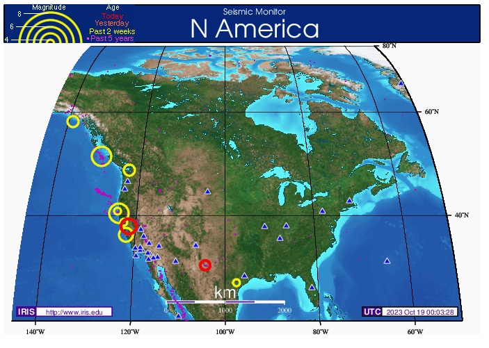
Things start to moving ie: Quake Swarms in both Honduras and Nicaragua: Data Follow: NICARAGUA EARTHQUAKES CENTER https://ineter.gob.ni/articulos/areas-t ... nitoreo-... 23/07/28 18:38:13 13.100 -87.550 6 1.9 C 12 Km al noroeste de Potosi, Cosiguina, Nicaragua 23/07/28 18:21:21 12.630 -88.250 29 3.2 C 62 Km al sur de Playa El Cuco, El Salvador 23/07/28 17:21:53 13.120 -87.530 4 2.5 C 14 Km al norte de Potosi, Cosiguina, Nicaragua 23/07/28 16:16:46 13.120 -87.530 4 2.3 C 14 Km al norte de Potosi, Cosiguina, Nicaragua 23/07/28 16:13:41 12.990 -87.590 17 1.8 C 3 Km al noroeste de Volcán Cosiguina, Nicaragua 23/07/28 16:04:32 12.690 -88.140 49 2.4 C 54 Km al sur de Playa El Cuco, El Salvador 23/07/28 15:27:58 13.080 -87.530 1 2.1 C 9 Km al norte de Potosi, Cosiguina, Nicaragua 23/07/28 12:56:50 12.430 -87.710 34 2.7 C 44 Km al suroeste de Jiquilillo, Nicaragua 23/07/28 12:51:34 13.110 -87.550 3 1.6 C 13 Km al noroeste de Potosi, Cosiguina, Nicaragua 23/07/28 12:45:00 13.120 -87.580 5 0.9 C 16 Km al noroeste de Potosi, Cosiguina, Nicaragua 23/07/28 12:38:26 13.100 -87.550 5 1.8 C 12 Km al noroeste de Potosi, Cosiguina, Nicaragua 23/07/28 12:36:35 13.110 -87.530 3 2.2 C 13 Km al norte de Potosi, Cosiguina, Nicaragua 23/07/28 12:18:28 13.110 -87.560 4 2.5 C 14 Km al noroeste de Potosi, Cosiguina, Nicaragua 23/07/28 11:57:40 12.660 -88.270 22 3.0 C 60 Km al sur de Playa El Cuco, El Salvador 23/07/28 11:55:25 13.100 -87.550 3 2.4 C 12 Km al noroeste de Potosi, Cosiguina, Nicaragua 23/07/28 11:50:16 13.110 -87.550 4 1.6 C 13 Km al noroeste de Potosi, Cosiguina, Nicaragua 23/07/28 11:23:57 12.660 -88.260 33 2.9 C 59 Km al sur de Playa El Cuco, El Salvador 23/07/28 10:57:00 13.110 -87.560 4 1.4 C 14 Km al noroeste de Potosi, Cosiguina, Nicaragua 23/07/28 10:47:17 13.270 -91.040 5 3.3 C 74 Km al sur de Sipacate, Guatemala 23/07/28 10:38:03 13.100 -87.530 4 3.0 C 12 Km al norte de Potosi, Cosiguina, Nicaragua 23/07/28 09:49:59 12.520 -88.110 25 2.5 C 63 Km al suroeste de Punta Cosigüina, Nicaragua 23/07/28 09:14:25 12.650 -88.230 16 2.2 C 60 Km al sur de Playa El Cuco, El Salvador 23/07/28 09:09:44 13.100 -87.540 4 2.6 C 12 Km al norte de Potosi, Cosiguina, Nicaragua 23/07/28 09:07:36 13.090 -87.550 2 1.0 C 11 Km al noroeste de Potosi, Cosiguina, Nicaragua 23/07/28 08:33:50 13.090 -87.520 2 1.6 C 10 Km al norte de Potosi, Cosiguina, Nicaragua 23/07/28 08:26:22 13.110 -87.530 3 2.9 C 13 Km al norte de Potosi, Cosiguina, Nicaragua 23/07/28 08:19:32 13.110 -87.550 4 2.7 C 13 Km al noroeste de Potosi, Cosiguina, Nicaragua 23/07/28 08:11:48 13.110 -87.540 4 2.7 C 13 Km al norte de Potosi, Cosiguina, Nicaragua 23/07/28 08:08:07 13.110 -87.550 3 2.3 C 13 Km al noroeste de Potosi, Cosiguina, Nicaragua 23/07/28 08:02:13 13.120 -87.560 3 1.1 C 15 Km al noroeste de Potosi, Cosiguina, Nicaragua 23/07/28 07:51:49 13.100 -87.550 4 2.9 C 12 Km al noroeste de Potosi, Cosiguina, Nicaragua 23/07/28 07:37:13 12.660 -88.310 33 3.3 C 61 Km al sur de Playa El Cuco, El Salvador 23/07/28 07:32:05 13.110 -87.530 3 2.6 C 13 Km al norte de Potosi, Cosiguina, Nicaragua 23/07/28 07:20:22 13.100 -87.560 6 3.2 C 13 Km al noroeste de Potosi, Cosiguina, Nicaragua 23/07/28 07:18:27 13.100 -87.530 4 3.2 C 12 Km al norte de Potosi, Cosiguina, Nicaragua 23/07/28 07:05:06 13.110 -87.550 3 2.5 C 13 Km al noroeste de Potosi, Cosiguina, Nicaragua 23/07/28 06:57:38 14.740 -92.300 79 3.2 C 19 Km al sur de Tapachula, México 23/07/28 06:50:58 13.120 -87.530 4 1.4 C 14 Km al norte de Potosi, Cosiguina, Nicaragua 23/07/28 06:44:43 13.090 -87.560 5 2.6 C 12 Km al noroeste de Potosi, Cosiguina, Nicaragua 23/07/28 06:38:15 13.110 -87.540 4 2.7 C 13 Km al norte de Potosi, Cosiguina, Nicaragua 23/07/28 06:35:43 13.110 -87.540 5 2.8 C 13 Km al norte de Potosi, Cosiguina, Nicaragua 23/07/28 06:28:50 13.120 -87.550 4 2.6 C 14 Km al norte de Potosi, Cosiguina, Nicaragua 23/07/28 06:24:12 13.110 -87.560 6 2.1 C 14 Km al noroeste de Potosi, Cosiguina, Nicaragua 23/07/28 06:18:53 13.120 -87.530 4 2.9 C 14 Km al norte de Potosi, Cosiguina, Nicaragua 23/07/28 06:12:34 13.110 -87.530 3 2.8 C 13 Km al norte de Potosi, Cosiguina, Nicaragua 23/07/28 05:56:21 13.100 -87.570 6 2.7 C 13 Km al noroeste de Potosi, Cosiguina, Nicaragua 23/07/28 05:46:14 13.110 -87.540 4 2.7 C 13 Km al norte de Potosi, Cosiguina, Nicaragua 23/07/28 05:35:36 13.130 -87.540 5 2.9 C 15 Km al norte de Potosi, Cosiguina, Nicaragua 23/07/28 05:32:59 13.110 -87.550 3 2.4 C 13 Km al noroeste de Potosi, Cosiguina, Nicaragua 23/07/28 05:24:04 13.120 -87.540 4 2.8 C 14 Km al norte de Potosi, Cosiguina, Nicaragua 23/07/28 05:21:14 13.120 -87.550 4 2.5 C 14 Km al norte de Potosi, Cosiguina, Nicaragua 23/07/28 05:19:06 13.120 -87.540 5 2.2 C 14 Km al norte de Potosi, Cosiguina, Nicaragua 23/07/28 05:10:59 13.100 -87.550 3 2.5 C 12 Km al noroeste de Potosi, Cosiguina, Nicaragua 23/07/28 05:05:21 13.110 -87.520 7 2.8 C 12 Km al norte de Potosi, Cosiguina, Nicaragua 23/07/28 05:04:23 13.110 -87.590 12 2.4 C 16 Km al noroeste de Potosi, Cosiguina, Nicaragua 23/07/28 04:59:10 13.110 -87.550 3 2.2 C 13 Km al noroeste de Potosi, Cosiguina, Nicaragua 23/07/28 04:56:29 13.110 -87.540 4 2.5 C 13 Km al norte de Potosi, Cosiguina, Nicaragua 23/07/28 04:48:58 13.110 -87.560 4 2.4 C 14 Km al noroeste de Potosi, Cosiguina, Nicaragua 23/07/28 04:46:04 13.120 -87.540 4 2.8 C 14 Km al norte de Potosi, Cosiguina, Nicaragua 23/07/28 04:44:14 14.900 -93.880 1 4.4 C 106 Km al sur de Buenavista, México 23/07/28 04:42:50 13.120 -87.540 5 2.4 C 14 Km al norte de Potosi, Cosiguina, Nicaragua 23/07/28 04:37:42 13.110 -87.550 3 2.0 C 13 Km al noroeste de Potosi, Cosiguina, Nicaragua 23/07/28 04:28:49 13.130 -87.540 3 2.5 C 15 Km al norte de Potosi, Cosiguina, Nicaragua 23/07/28 04:23:02 13.110 -87.540 3 2.5 C 13 Km al norte de Potosi, Cosiguina, Nicaragua 23/07/28 04:04:34 13.120 -87.530 3 1.9 C 14 Km al norte de Potosi, Cosiguina, Nicaragua 23/07/28 03:52:09 12.470 -87.690 36 2.6 C 40 Km al suroeste de Jiquilillo, Nicaragua 23/07/28 03:39:10 13.120 -87.530 3 2.4 C 14 Km al norte de Potosi, Cosiguina, Nicaragua 23/07/28 03:04:55 9.900 -84.680 33 3.5 C 15 Km al sureste de Chacarita, Costa Rica 23/07/28 02:55:53 13.110 -87.550 3 2.4 C 13 Km al noroeste de Potosi, Cosiguina, Nicaragua 23/07/28 02:19:14 13.140 -87.520 3 2.8 C 16 Km al norte de Potosi, Cosiguina, Nicaragua 23/07/28 02:12:36 13.660 -90.090 86 3.0 C 26 Km al sureste de Las Brisas, Guatemala 23/07/28 02:08:06 12.610 -88.180 24 2.7 C 63 Km al suroeste de Punta Cosigüina, Nicaragua 23/07/28 01:57:17 13.110 -87.560 6 2.2 C 14 Km al noroeste de Potosi, Cosiguina, Nicaragua 23/07/28 01:08:00 13.080 -87.530 4 2.6 C 9 Km al norte de Potosi, Cosiguina, Nicaragua 23/07/28 00:32:25 13.350 -88.720 1 2.9 C 16 Km al noreste de Delta del Rio Lempa, El Salvador 23/07/28 00:17:57 12.620 -88.200 24 2.8 C 62 Km al sur de Playa El Cuco, El Salvador 23/07/27 23:23:11 13.110 -87.540 5 2.2 C 13 Km al norte de Potosi, Cosiguina, Nicaragua 23/07/27 23:12:19 13.110 -87.530 6 2.6 C 13 Km al norte de Potosi, Cosiguina, Nicaragua 23/07/27 23:08:31 13.090 -87.600 7 1.9 C 14 Km al norte de Volcán Cosiguina, Nicaragua 23/07/27 22:41:32 13.120 -87.550 5 2.9 C 14 Km al norte de Potosi, Cosiguina, Nicaragua 23/07/27 22:17:20 13.130 -87.540 3 2.9 C 15 Km al norte de Potosi, Cosiguina, Nicaragua 23/07/27 22:01:40 13.110 -87.540 5 2.6 C 13 Km al norte de Potosi, Cosiguina, Nicaragua 23/07/27 21:53:10 13.120 -87.540 5 2.4 C 14 Km al norte de Potosi, Cosiguina, Nicaragua 23/07/27 21:28:12 13.140 -87.530 4 2.7 C 16 Km al norte de Potosi, Cosiguina, Nicaragua 23/07/27 21:09:18 13.130 -87.550 4 2.9 C 15 Km al norte de Potosi, Cosiguina, Nicaragua 23/07/27 21:01:21 13.130 -87.560 4 2.8 C 16 Km al noroeste de Potosi, Cosiguina, Nicaragua 23/07/27 20:55:27 13.130 -87.560 4 2.5 C 16 Km al noroeste de Potosi, Cosiguina, Nicaragua 23/07/27 20:48:59 13.130 -87.540 5 3.1 C 15 Km al norte de Potosi, Cosiguina, Nicaragua 23/07/27 20:43:20 13.130 -87.550 4 2.6 C 15 Km al norte de Potosi, Cosiguina, Nicaragua 23/07/27 20:30:33 13.130 -87.530 4 2.4 C 15 Km al norte de Potosi, Cosiguina, Nicaragua 23/07/27 20:26:21 13.120 -87.550 5 2.6 C 14 Km al norte de Potosi, Cosiguina, Nicaragua 23/07/27 20:18:19 13.130 -87.540 3 2.8 C 15 Km al norte de Potosi, Cosiguina, Nicaragua 23/07/27 20:10:10 13.140 -87.520 4 2.9 C 16 Km al norte de Potosi, Cosiguina, Nicaragua 23/07/27 20:06:33 14.660 -88.690 3 3.5 C 14 Km al noroeste de Gracias, Lempira, Honduras 23/07/27 19:57:10 13.110 -87.540 7 2.7 C 13 Km al norte de Potosi, Cosiguina, Nicaragua 23/07/27 19:54:33 13.130 -87.570 3 2.2 C 16 Km al noroeste de Potosi, Cosiguina, Nicaragua 23/07/27 19:50:06 13.130 -87.540 5 3.0 C 15 Km al norte de Potosi, Cosiguina, Nicaragua 23/07/27 19:45:30 13.120 -87.540 4 2.6 C 14 Km al norte de Potosi, Cosiguina, Nicaragua 23/07/27 19:35:47 13.100 -87.530 4 3.4 C 12 Km al norte de Potosi, Cosiguina, Nicaragua 23/07/27 19:28:36 13.120 -87.540 4 2.8 C 14 Km al norte de Potosi, Cosiguina, Nicaragua 23/07/27 19:23:03 13.130 -87.540 3 2.8 C 15 Km al norte de Potosi, Cosiguina, Nicaragua 23/07/27 19:20:25 13.120 -87.540 4 3.0 C 14 Km al norte de Potosi, Cosiguina, Nicaragua 23/07/27 19:07:14 13.140 -89.940 21 3.0 C 51 Km al sur de Acajutla, El Salvador 23/07/27 18:59:51 13.110 -87.540 3 2.1 C 13 Km al norte de Potosi, Cosiguina, Nicaragua 23/07/27 18:58:30 13.100 -87.520 3 2.1 C 11 Km al norte de Potosi, Cosiguina, Nicaragua 23/07/27 18:52:02 13.120 -87.560 4 2.3 C 15 Km al noroeste de Potosi, Cosiguina, Nicaragua 23/07/27 18:38:47 13.110 -87.530 5 3.4 C 13 Km al norte de Potosi, Cosiguina, Nicaragua 23/07/27 18:27:59 13.090 -87.520 5 2.2 C 10 Km al norte de Potosi, Cosiguina, Nicaragua 23/07/27 18:20:47 13.430 -90.580 9 2.9 C 55 Km al suroeste de Las Brisas, Guatemala 23/07/27 17:29:51 13.160 -87.530 2 2.8 C 18 Km al norte de Potosi, Cosiguina, Nicaragua 23/07/27 17:23:57 13.150 -87.520 4 2.4 C 17 Km al norte de Potosi, Cosiguina, Nicaragua 23/07/27 17:22:51 13.100 -87.550 4 2.5 C 12 Km al noroeste de Potosi, Cosiguina, Nicaragua 23/07/27 16:55:42 13.120 -87.560 12 3.3 C 15 Km al noroeste de Potosi, Cosiguina, Nicaragua 23/07/27 16:42:28 13.120 -87.540 5 2.5 C 14 Km al norte de Potosi, Cosiguina, Nicaragua 23/07/27 16:21:08 13.120 -87.540 4 2.8 C 14 Km al norte de Potosi, Cosiguina, Nicaragua 23/07/27 16:17:03 13.100 -87.530 5 2.0 C 12 Km al norte de Potosi, Cosiguina, Nicaragua 23/07/27 16:11:05 13.110 -87.560 6 3.4 C 14 Km al noroeste de Potosi, Cosiguina, Nicaragua 23/07/27 16:08:16 15.490 -93.410 78 4.3 C 29 Km al sur de San Isidro, México 23/07/27 16:04:59 13.120 -87.530 3 2.6 C 14 Km al norte de Potosi, Cosiguina, Nicaragua 23/07/27 16:04:58 13.070 -87.560 11 2.3 C 10 Km al noroeste de Potosi, Cosiguina, Nicaragua 23/07/27 15:35:02 13.100 -87.530 4 1.0 C 12 Km al norte de Potosi, Cosiguina, Nicaragua 23/07/27 15:26:31 13.110 -87.550 2 2.4 C 13 Km al noroeste de Potosi, Cosiguina, Nicaragua 23/07/27 13:55:55 13.120 -87.540 3 2.7 C 14 Km al norte de Potosi, Cosiguina, Nicaragua 23/07/27 13:36:14 13.100 -87.530 5 2.7 C 12 Km al norte de Potosi, Cosiguina, Nicaragua 23/07/27 13:08:55 13.110 -87.540 6 2.7 C 13 Km al norte de Potosi, Cosiguina, Nicaragua 23/07/27 13:06:13 13.120 -87.540 5 2.0 C 14 Km al norte de Potosi, Cosiguina, Nicaragua 23/07/27 12:57:22 13.130 -87.540 4 2.3 C 15 Km al norte de Potosi, Cosiguina, Nicaragua 23/07/27 12:48:17 13.080 -87.550 11 2.3 C 10 Km al noroeste de Potosi, Cosiguina, Nicaragua 23/07/27 12:43:38 13.160 -87.520 15 2.5 C 18 Km al norte de Potosi, Cosiguina, Nicaragua 23/07/27 12:29:20 13.120 -87.560 4 2.7 C 15 Km al noroeste de Potosi, Cosiguina, Nicaragua 23/07/27 12:18:47 13.110 -87.600 1 2.5 C 16 Km al norte de Volcán Cosiguina, Nicaragua 23/07/27 12:16:19 9.770 -83.860 9 2.9 C 10 Km al noreste de Tres de Junio, Costa Rica 23/07/27 11:59:25 13.090 -87.580 9 2.8 C 13 Km al noroeste de Potosi, Cosiguina, Nicaragua 23/07/27 11:57:05 13.060 -87.610 16 2.5 C 11 Km al norte de Volcán Cosiguina, Nicaragua 23/07/27 11:50:50 13.110 -87.550 8 2.8 C 13 Km al noroeste de Potosi, Cosiguina, Nicaragua 23/07/27 11:45:00 13.120 -87.530 8 3.1 C 14 Km al norte de Potosi, Cosiguina, Nicaragua 23/07/27 11:42:15 13.130 -87.540 4 2.8 C 15 Km al norte de Potosi, Cosiguina, Nicaragua 23/07/27 11:37:12 13.120 -87.550 5 2.8 C 14 Km al norte de Potosi, Cosiguina, Nicaragua 23/07/27 11:35:10 13.110 -87.550 8 3.1 C 13 Km al noroeste de Potosi, Cosiguina, Nicaragua 23/07/27 11:31:59 13.120 -87.540 4 2.8 C 14 Km al norte de Potosi, Cosiguina, Nicaragua 23/07/27 11:26:59 13.110 -87.550 4 3.3 C 13 Km al noroeste de Potosi, Cosiguina, Nicaragua 23/07/27 11:24:23 13.120 -87.540 4 3.0 C 14 Km al norte de Potosi, Cosiguina, Nicaragua 23/07/27 11:18:48 13.120 -87.540 8 3.0 C 14 Km al norte de Potosi, Cosiguina, Nicaragua 23/07/27 11:15:26 13.110 -87.550 7 2.9 C 13 Km al noroeste de Potosi, Cosiguina, Nicaragua 23/07/27 11:13:49 13.120 -87.550 6 2.4 C 14 Km al norte de Potosi, Cosiguina, Nicaragua 23/07/27 11:05:51 13.100 -87.540 4 2.9 C 12 Km al norte de Potosi, Cosiguina, Nicaragua 23/07/27 11:04:05 13.110 -87.560 3 2.1 C 14 Km al noroeste de Potosi, Cosiguina, Nicaragua 23/07/27 10:54:38 13.080 -87.520 2 1.4 C 9 Km al norte de Potosi, Cosiguina, Nicaragua 23/07/27 10:44:16 13.100 -87.550 6 2.5 C 12 Km al noroeste de Potosi, Cosiguina, Nicaragua 23/07/27 10:39:03 13.100 -87.550 7 2.0 C 12 Km al noroeste de Potosi, Cosiguina, Nicaragua Honduras Earthquake Report https://earthquakelist.org/honduras/ DATE AND TIME MAGNITUDE LOCATION 1 hour ago (Jul 28 06:21PM Tegucigalpa) M 3.2 197 km SW from Tegucigalpa 2 hours ago (Jul 28 05:21PM Tegucigalpa) M 2.5 42 km WSW from Ciudad Choluteca 3 hours ago (Jul 28 03:28PM Tegucigalpa) M 2.7 2 km WSW from Ciudad Choluteca 6 hours ago (Jul 28 12:56PM Tegucigalpa) M 2.7 192 km SSW from Tegucigalpa 7 hours ago (Jul 28 12:18PM Tegucigalpa) M 2.5 45 km WSW from Ciudad Choluteca 7 hours ago (Jul 28 11:57AM Tegucigalpa) M 3.0 196 km SW from Tegucigalpa 8 hours ago (Jul 28 11:23AM Tegucigalpa) M 2.9 195 km SW from Tegucigalpa 8 hours ago (Jul 28 10:38AM Tegucigalpa) M 3.0 43 km WSW from Ciudad Choluteca 9 hours ago (Jul 28 09:49AM Tegucigalpa) M 2.5 200 km SSW from Tegucigalpa 10 hours ago (Jul 28 09:09AM Tegucigalpa) M 2.6 44 km WSW from Ciudad Choluteca 11 hours ago (Jul 28 08:26AM Tegucigalpa) M 2.6 41 km WSW from Ciudad Choluteca 11 hours ago (Jul 28 08:19AM Tegucigalpa) M 2.7 44 km WSW from Ciudad Choluteca 11 hours ago (Jul 28 08:11AM Tegucigalpa) M 2.5 42 km WSW from Ciudad Choluteca 11 hours ago (Jul 28 07:51AM Tegucigalpa) M 2.8 46 km WSW from Ciudad Choluteca 11 hours ago (Jul 28 07:37AM Tegucigalpa) M 3.3 198 km SW from Tegucigalpa 11 hours ago (Jul 28 07:32AM Tegucigalpa) M 2.6 42 km WSW from Ciudad Choluteca 12 hours ago (Jul 28 07:20AM Tegucigalpa) M 3.2 46 km WSW from Ciudad Choluteca 12 hours ago (Jul 28 07:18AM Tegucigalpa) M 3.2 43 km WSW from Ciudad Choluteca 12 hours ago (Jul 28 07:05AM Tegucigalpa) M 2.6 45 km WSW from Ciudad Choluteca 12 hours ago (Jul 28 06:44AM Tegucigalpa) M 2.6 46 km WSW from Ciudad Choluteca 12 hours ago (Jul 28 06:38AM Tegucigalpa) M 2.7 43 km WSW from Ciudad Choluteca 12 hours ago (Jul 28 06:35AM Tegucigalpa) M 2.8 43 km WSW from Ciudad Choluteca 12 hours ago (Jul 28 06:28AM Tegucigalpa) M 2.6 44 km WSW from Ciudad Choluteca 13 hours ago (Jul 28 06:18AM Tegucigalpa) M 2.9 42 km WSW from Ciudad Choluteca 13 hours ago (Jul 28 06:12AM Tegucigalpa) M 2.8 43 km WSW from Ciudad Choluteca |
Author: | recall15 [ Wed Oct 18, 2023 5:11 pm ] |
Post subject: | Re: today's earthquakes |
Just for the Records: Via: http://ds.iris.edu/seismon/index.phtml |
Author: | recall15 [ Wed Nov 08, 2023 5:58 pm ] |
Post subject: | Re: today's earthquakes |
Then: New Madrid Jolt timeline - November 2023 (1) Quote: On November 8 there was a mega jolt of several quakes mag 7- in Indonesia at the Banda Sea. China had quakes inland and the Triangle was highlighted too. Because the Banda Sea quakes were so strong I was anticipating a void in the S Pacific being created with S America dropping into the void and within hours Texas quakes emerged with explosive consequences. Quote: Notes: (1) https://poleshift.ning.com/profiles/blo ... e=activity |
Author: | recall15 [ Wed Nov 22, 2023 2:40 pm ] |
Post subject: | Re: today's earthquakes |
recall15 wrote: Looking Glass event #20 November 28, 2023 Evil Orions and their evil STS human alliance wants to mess (turn it on Harpp) with The Yellowstone supervolcano -snip- So the STS ORIONS and their evil Human Minions start messing with Yellowstone: see: |
Author: | recall15 [ Mon Dec 04, 2023 7:03 am ] |
Post subject: | Re: today's earthquakes |
Sunday December 03 Via: www.weather.gov/ |
Author: | recall15 [ Mon Dec 04, 2023 7:04 am ] |
Post subject: | Re: today's earthquakes |
Else: USGS 4.9 Fiji region 2023-12-02 17:24:23 (UTC-03:00) 526.3 km 5.3 40 km NE of Hinatuan, Philippines 2023-12-02 16:57:09 (UTC-03:00) 75.8 km 5.1 20 km ENE of Santa Maria, Philippines 2023-12-02 16:54:18 (UTC-03:00) 67.4 km 5.2 Mindanao, Philippines 2023-12-02 16:37:03 (UTC-03:00) 61.2 km 5.4 53 km ENE of Barcelona, Philippines 2023-12-02 16:19:23 (UTC-03:00) 34.6 km 5.4 53 km ENE of Barcelona, Philippines 2023-12-02 16:19:23 (UTC-03:00) 34.6 k 5.4 49 km ENE of Hinatuan, Philippines 2023-12-02 15:20:41 (UTC-03:00) 62.4 km 6.2 62 km ENE of Barcelona, Philippines 2023-12-02 15:09:26 (UTC-03:00) 54.9 km https://earthquake.usgs.gov/earthquakes ... /executive 5.2 Mindanao, Philippines 2023-12-02 15:01:23 (UTC-03:00) 42.5 km 5.7 53 km ESE of Marihatag, Philippines 2023-12-02 14:55:26 (UTC-03:00) 52.2 km 6.2 Mindanao, Philippines 2023-12-02 14:40:12 (UTC-03:00) 18.0 km 5.1 55 km ESE of Marihatag, Philippines 2023-12-02 14:31:38 (UTC-03:00) 41.5 km 4.7 62 km NE of Barcelona, Philippines 2023-12-02 14:26:54 (UTC-03:00) 62.9 km 4.9 Mindanao, Philippines 2023-12-02 14:16:08 (UTC-03:00) 69.9 km 5.3 33 km NE of Barcelona, Philippines 2023-12-02 14:02:02 (UTC-03:00) 59.0 km 5.7 59 km ENE of Barcelona, Philippines 2023-12-02 13:53:09 (UTC-03:00) 51.9 km 4.8 Mindanao, Philippines 2023-12-02 13:47:20 (UTC-03:00) 56.4 km 5.4 47 km ENE of Hinatuan, Philippines 2023-12-02 13:34:58 (UTC-03:00) 58.3 km 5.1 41 km NE of Barcelona, Philippines 2023-12-02 13:34:26 (UTC-03:00) 53.8 km 4.7 38 km ENE of Hinatuan, Philippines 2023-12-02 13:33:40 (UTC-03:00) 52.4 km 5.7 40 km ENE of Barcelona, Philippines 2023-12-02 13:19:47 (UTC-03:00) 62.4 km 5.6 Mindanao, Philippines 2023-12-02 13:17:01 (UTC-03:00) 47.5 km 5.2 Mindanao, Philippines 2023-12-02 13:13:22 (UTC-03:00) 53.1 km M 6.4 - 47 km NE of Barcelona, Philippines 2023-12-02 16:03:43 (UTC)8.415°N 126.776°E64.3 km depth https://earthquake.usgs.gov/earthquakes ... /executive 4.9 65 km ENE of Barcelona, Philippines 2023-12-02 12:54:10 (UTC-03:00) 54.4 km 5.2 55 km ENE of Hinatuan, Philippines 2023-12-02 12:50:41 (UTC-03:00) 61.5 km 5.3 Mindanao, Philippines 2023-12-02 12:46:24 (UTC-03:00) 56.6 km 5.3 58 km NE of Barcelona, Philippines 2023-12-02 12:42:48 (UTC-03:00) 27.4 km 4.9 81 km ENE of Barcelona, Philippines 2023-12-02 12:38:25 (UTC-03:00) 53.9 km 5.5 49 km ENE of Hinatuan, Philippines 2023-12-02 12:31:27 (UTC-03:00) 48.3 km 5.0 68 km ENE of Barcelona, Philippines 2023-12-02 12:29:32 (UTC-03:00) 36.3 km 5.4 40 km NE of Barcelona, Philippines 2023-12-02 12:22:04 (UTC-03:00) 48.4 km 5.1 25 km E of Santa Maria, Philippines 2023-12-02 12:21:00 (UTC-03:00) 11.3 km 5.8 Philippine Islands region 2023-12-02 12:06:46 (UTC-03:00) 60.3 km 5.3 Mindanao, Philippines 2023-12-02 12:00:08 (UTC-03:00) 40.5 km ----------------------------------------------------------- M 5.5 - west of Macquarie Island 2023-12-02 14:02:10 (UTC)55.720°S 147.018°E10.0 km depth https://earthquake.usgs.gov/earthquakes ... /executive M 5.5 - Kepulauan Babar, Indonesia 2023-12-02 12:01:01 (UTC)7.022°S 129.691°E121.3 km depth 5.1 Maug Islands region, Northern Mariana Islands 2023-12-02 08:58:17 (UTC-03:00) 10.0 km 4.5 Jujuy, Argentina 2023-12-02 08:02:53 (UTC-03:00) 193.4 km 4.5 55 km N of Beauséjour, Guadeloupe 2023-12-02 07:29:13 (UTC-03:00) 37.8 km https://earthquake.usgs.gov/earthquakes ... /executive 5.1 96 km S of Antofagasta, Chile 2023-12-02 06:31:32 (UTC-03:00) 40.2 km 5.2 43 km NE of Anse-Bertrand, Guadeloupe 2023-12-02 05:48:24 (UTC-03:00) 41.3 km 5.8 40 km ENE of Camiña, Chile 2023-12-02 04:55:40 (UTC-03:00) 105.8 km 5.0 South Sandwich Islands region 2023-12-02 02:03:54 (UTC-03:00) 143.6 km M 5.5 - 10 km ENE of Rāmganj, Bangladesh 2023-12-02 03:35:32 (UTC)23.124°N 90.945°E38.5 km depth https://earthquake.usgs.gov/earthquakes ... /executive 4.9 58 km NE of Beauséjour, Guadeloupe 2023-12-02 00:00:45 (UTC-03:00) 36.9 km 4.9 Peru-Brazil border region 2023-12-01 23:23:18 (UTC-03:00) 10.0 km M 4.3 - 74 km S of Hualien City, Taiwan Magnitude 4.2 Region MYANMAR-CHINA BORDER REGION Date time 2023-12-01 18:24:58.3 UTC Location 24.233 ; 98.048 Depth 14 km Magnitude 5.0 Region MYANMAR-CHINA BORDER REGION Date time 2023-12-01 17:36:35.0 UTC Location 24.311 ; 98.215 Depth 10 km Magnitude 5.4 Region GANSU, CHINA Date time 2023-12-01 14:55:57.7 UTC Location 39.220 ; 97.288 Depth 10 km https://www.emsc-csem.org/Earthquake_in ... .php?id=... |
Author: | recall15 [ Wed Dec 27, 2023 3:26 pm ] |
Post subject: | Re: today's earthquakes |
Then: A quake 6.7 mi south of Port Huron, St. Clair County, Michigan, USA, Dec 27, 2023 10:47 am (Detroit time) (1) Notes: (1) https://www.volcanodiscovery.com/app/ea ... THh5O096Po |
Author: | recall15 [ Tue Jan 02, 2024 11:25 am ] |
Post subject: | Re: today's earthquakes |
Just for the Records: January 1 2024 (1) Quote: TOKYO, Jan 1 (Reuters) - A powerful earthquake struck central Japan on Monday, killing at least one person, destroying buildings, knocking out power to tens of thousands of homes and prompting residents in some coastal areas to flee to higher ground. The quake with a preliminary magnitude of 7.6 triggered waves of about 1 metre along Japan's west coast and neighbouring South Korea. The Japan Meteorological Agency (JMA) initially issued a major tsunami warning - its first since the March 2011 earthquake and tsunami that struck northeast Japan killing nearly 20,000 people - for Ishikawa prefecture. It later downgraded that and eventually cut it to an advisory. Notes: (1) https://www.reuters.com/world/japan/mag ... 024-01-01/ |
Author: | recall15 [ Thu Jan 04, 2024 1:58 pm ] |
Post subject: | Re: today's earthquakes |
New Madrid Jolt timeline - January 2024 (1) Pic:(1) Notes: (1) https://poleshift.ning.com/profiles/blo ... e=activity |
Author: | recall15 [ Wed Feb 07, 2024 8:42 am ] |
Post subject: | Re: today's earthquakes |
New Madrid Jolt timeline - February 2024 (1) Quote: On February 5-6 the N Atlantic Ridge exploded in a dozen Mag 5+ quakes. This is where the Mainland of N America is pulling to the West.. When the Azores opens up a void, allowing a big water slosh toward Europe (propelled by the Gulf Stream) it is likely to be in this location. Quote: Notes: (1) https://poleshift.ning.com/profiles/blo ... e=activity |
Author: | recall15 [ Mon Feb 12, 2024 7:19 am ] |
Post subject: | Re: today's earthquakes |
San Diego CA Quake Swarm: (1) Quote: Residents reported decorations falling from the walls and breaking as the quake was felt across the area. According to United States Geological Survey (USGS) 15 earthquakes have so far hit in the space of an hour. People from as far as San Diego to Yuma, Arizona, reported feeling the earth shake. Notes: (1) https://www.mirror.co.uk/news/us-news/b ... e-32103778 |
Page 1 of 1 | All times are UTC - 8 hours [ DST ] |
Powered by phpBB © 2000, 2002, 2005, 2007 phpBB Group http://www.phpbb.com/ |