|
It is currently Thu May 02, 2024 1:44 pm |
|
All times are UTC - 8 hours [ DST ] |
|
|
Page 1 of 1 |
[ 14 posts ] |
| Print view | Previous topic | Next topic |
Hurricane Earl
| Author | Message |
|---|---|
|
Site Admin  Joined: Sun Oct 11, 2009 8:59 am Posts: 6532 Location: Friendswood, TX |
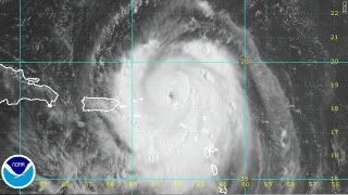
Those of you living on the East Coast of the US need to pay particular attention to this storm.
Get your hurricane supplies ready NOW! Don't get caught in the crush of last minute shoppers. Gas the car(s). Fill your prescriptions NOW - don't wait until the last minute to do this. Get money out of the bank NOW - ATM's quickly run out of cash. You will need small bills - not hundreds. Be prepared to live without electricity - buy non-perishable foods NOW. Be prepared to live with no help for at least 72 hours after landfall. Stock up on ice - ice is life with no electricity. Stock up on water. Put your frozen food in large garbage bags NOW in the event you lose electricity. Be smart and be safe.  Miami, Florida (CNN) -- Hurricane Earl was slowly strengthening in the Atlantic on Monday as it passed over the northern Leeward Islands on its way to the Virgin Islands, forecasters said. Earl remained a Category 2 hurricane as of Monday, but its winds were getting stronger, the National Hurricane Center said. As of 8 a.m. ET, Earl's maximum sustained winds were at 110 mph (175 kph) with higher gusts. Its center was about 25 miles (40 kilometers) northeast of St. Martin and about 140 miles (220 km) east of St. Thomas in the U.S. Virgin Islands. It was moving west-northwest at 14 mph (22 kph). snip Earl could affect areas in the United States from the Carolinas to Cape Cod, Massachusetts, over Labor Day weekend, said CNN meteorologist Jacqui Jeras. It is too soon to tell whether the storm could make landfall, she said. However, outer bands of the storm are likely to hit North Carolina beginning Thursday, kicking up large swells and possibly generating rip currents through Labor Day weekend, Jeras said. Read more here: http://www.cnn.com/2010/US/08/30/tropic ... tml?hpt=T1 _________________ The test of our progress is not whether we add more to the abundance of those who have much; it is whether we provide enough for those who have too little. - FDR |
| Mon Aug 30, 2010 6:33 am |
|
|
Site Admin Joined: Sun Oct 11, 2009 8:59 am Posts: 6532 Location: Friendswood, TX |
 Earl becomes a major hurricane Miami, Florida (CNN) -- Hurricane Earl strengthened into a major hurricane on Monday, forecasters said. It passed over the northern Leeward Islands on its way to the Virgin Islands, forecasters said. Earl grew into a Category 3 hurricane Monday morning, the National Hurricane Center said. As of 11 a.m. ET, Earl's maximum sustained winds were at 120 mph (193 kph). Read more here: http://www.cnn.com/2010/US/08/30/tropical.weather/index.html?hpt=T1 _________________ The test of our progress is not whether we add more to the abundance of those who have much; it is whether we provide enough for those who have too little. - FDR |
| Mon Aug 30, 2010 10:41 am |
|
|
GT Truther  Joined: Tue Apr 20, 2010 9:31 pm Posts: 2831 Location: Fennell bay N.S.W. (AUS) |
Bluebonnet wrote: Those of you living on the East Coast of the US need to pay particular attention to this storm. Get your hurricane supplies ready NOW! Don't get caught in the crush of last minute shoppers. Gas the car(s). Fill your prescriptions NOW - don't wait until the last minute to do this. Get money out of the bank NOW - ATM's quickly run out of cash. You will need small bills - not hundreds. Be prepared to live without electricity - buy non-perishable foods NOW. Be prepared to live with no help for at least 72 hours after landfall. Stock up on ice - ice is life with no electricity. Stock up on water. Put your frozen food in large garbage bags NOW in the event you lose electricity. Be smart and be safe. Miami, Florida (CNN) -- Hurricane Earl was slowly strengthening in the Atlantic on Monday as it passed over the northern Leeward Islands on its way to the Virgin Islands, forecasters said. Earl remained a Category 2 hurricane as of Monday, but its winds were getting stronger, the National Hurricane Center said. As of 8 a.m. ET, Earl's maximum sustained winds were at 110 mph (175 kph) with higher gusts. Its center was about 25 miles (40 kilometers) northeast of St. Martin and about 140 miles (220 km) east of St. Thomas in the U.S. Virgin Islands. It was moving west-northwest at 14 mph (22 kph). snip Earl could affect areas in the United States from the Carolinas to Cape Cod, Massachusetts, over Labor Day weekend, said CNN meteorologist Jacqui Jeras. It is too soon to tell whether the storm could make landfall, she said. However, outer bands of the storm are likely to hit North Carolina beginning Thursday, kicking up large swells and possibly generating rip currents through Labor Day weekend, Jeras said. Read more here: http://www.cnn.com/2010/US/08/30/tropic ... tml?hpt=T1 AND ABOVE ALL CALM THE H*LL DOWN!! IT'S ONLY A STORM!!! ANYONE GOT A PRIUS!! http://www.wikihow.com/Use-a-Toyota-Prius-As-a-Backup-Generator _________________ I am a HIGHLY STRUNG PRIMA DONNA (atari) |
| Mon Aug 30, 2010 9:11 pm |
|
|
Site Admin Joined: Sun Oct 11, 2009 8:59 am Posts: 6532 Location: Friendswood, TX |
Hurricane Earl moves away from Puerto Rico, could affect U.S.
Miami, Florida (CNN) -- After dealing a glancing blow to Puerto Rico and the Virgin Islands, Hurricane Earl was heading back out into the open Atlantic Tuesday, but forecasters warned the large and dangerous storm could have the Carolinas in its sights later this week. Earl quickly developed into a Category 4 storm on Monday, packing winds of 135 mph (215 kph). It also grew large, with hurricane-force winds stretching 70 miles (110 km) from its center and tropical storm-force winds extending outward some 200 miles (325 kilometers). "We don't expect it to weaken," CNN meteorologist Rob Marciano said Tuesday. "It may strengthen." As of 7 a.m. ET, the center of Earl was about 175 miles (280 kilometers) north-northwest of San Juan, Puerto Rico, and about 235 miles (380 kilometers) east-southeast of Grand Turk Island. It was heading north-northwest at about 13 mph (20 kph). http://www.cnn.com/2010/US/08/31/tropical.weather/index.html?hpt=T1 _________________ The test of our progress is not whether we add more to the abundance of those who have much; it is whether we provide enough for those who have too little. - FDR |
| Tue Aug 31, 2010 6:16 am |
|
|
Site Admin Joined: Sun Oct 11, 2009 8:59 am Posts: 6532 Location: Friendswood, TX |
Thousands flee as Hurricane Earl threatens East Coast
RALEIGH, N.C. — Hurricane Earl appeared to have turned toward the U.S. coast Wednesday, an NBC meteorologist said, with concern growing that New England could receive a direct hit later in the week. The National Hurricane Center also extended its hurricane watch from North Carolina into Virginia. In North Carolina, visitors to the islands of Ocracoke and Hatteras were ordered to leave with Earl — currently about 180 miles east of San Salvador in the Bahamas and 780 miles south-southeast of Cape Hatteras, North Carolina — expected to track up the coast. The 800 or so year-round residents of Ocracoke Island were told they did not have to go, but Emergency Services Director Lindsey Mooney said officials hoped they would follow about 5,000 tourists forced to leave for the mainland. Read more here: http://www.msnbc.msn.com/id/38877306/ns/weather/# _________________ The test of our progress is not whether we add more to the abundance of those who have much; it is whether we provide enough for those who have too little. - FDR |
| Wed Sep 01, 2010 6:23 am |
|
|
Site Admin Joined: Sun Oct 11, 2009 8:59 am Posts: 6532 Location: Friendswood, TX |
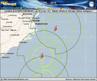 Thanks to Skeetobite @ Storm2K for the image. As you can see - any leftward wobble could be disasterous for North Carolina/Virginia. Here is a link to the Earl discussion there: http://www.storm2k.org/phpbb2/viewtopic.php?f=59&t=109110&start=3360 _________________ The test of our progress is not whether we add more to the abundance of those who have much; it is whether we provide enough for those who have too little. - FDR |
| Wed Sep 01, 2010 8:15 am |
|
|
Site Admin Joined: Sun Oct 11, 2009 8:59 am Posts: 6532 Location: Friendswood, TX |
000
WTNT32 KNHC 011455 TCPAT2 BULLETIN HURRICANE EARL ADVISORY NUMBER 29 NWS TPC/NATIONAL HURRICANE CENTER MIAMI FL AL072010 1100 AM EDT WED SEP 01 2010 ...LARGE HURRICANE EARL THREATENS PORTIONS OF THE MID ATLANTIC COAST...HURRICANE WARNINGS ISSUED... SUMMARY OF 1100 AM EDT...1500 UTC...INFORMATION ----------------------------------------------- LOCATION...25.1N 72.1W ABOUT 170 MI...270 KM ENE OF SAN SALVADOR ABOUT 725 MI...1170 KM SSE OF CAPE HATTERAS NORTH CAROLINA MAXIMUM SUSTAINED WINDS...125 MPH...205 KM/HR PRESENT MOVEMENT...NW OR 320 DEGREES AT 17 MPH...28 KM/HR MINIMUM CENTRAL PRESSURE...943 MB...27.85 INCHES WATCHES AND WARNINGS -------------------- CHANGES WITH THIS ADVISORY... A HURRICANE WARNING HAS BEEN ISSUED FOR THE EAST COAST OF THE UNITED STATES FROM BOGUE INLET NORTH CAROLINA NORTHEASTWARD TO THE NORTH CAROLINA/VIRGINIA BORDER...INCLUDING THE PAMLICO AND ALBEMARLE SOUNDS. THE HURRICANE WATCH HAS BEEN ADJUSTED NORTHWARD AND NOW EXTENDS FROM THE NORTH CAROLINA/VIRGINIA BORDER NORTHWARD TO CAPE HENLOPEN DELAWARE. A TROPICAL STORM WARNING HAS BEEN ISSUED FROM CAPE FEAR TO WEST OF BOGUE INLET. SUMMARY OF WATCHES AND WARNINGS IN EFFECT... A HURRICANE WARNING IS IN EFFECT FOR... * BOGUE INLET NORTH CAROLINA NORTHEASTWARD TO THE NORTH CAROLINA/VIRGINIA BORDER INCLUDING THE PAMLICO AND ALBEMARLE SOUNDS. A HURRICANE WATCH IS IN EFFECT FOR... * NORTH OF THE NORTH CAROLINA/VIRGINIA BORDER TO CAPE HENLOPEN DELAWARE. A TROPICAL STORM WARNING IS IN EFFECT FOR... * SAN SALVADOR ISLAND IN THE CENTRAL BAHAMAS * FROM CAPE FEAR TO WEST OF BOGUE INLET NORTH CAROLINA. A HURRICANE WARNING MEANS THAT HURRICANE CONDITIONS ARE EXPECTED SOMEWHERE WITHIN THE WARNING AREA. A WARNING IS TYPICALLY ISSUED 36 HOURS BEFORE THE ANTICIPATED FIRST OCCURRENCE OF TROPICAL-STORM-FORCE WINDS...CONDITIONS THAT MAKE OUTSIDE PREPARATIONS DIFFICULT OR DANGEROUS. PREPARATIONS TO PROTECT LIFE AND PROPERTY SHOULD BE RUSHED TO COMPLETION. A HURRICANE WATCH MEANS THAT HURRICANE CONDITIONS ARE POSSIBLE WITHIN THE WATCH AREA. A WATCH IS TYPICALLY ISSUED 48 HOURS BEFORE THE ANTICIPATED FIRST OCCURRENCE OF TROPICAL-STORM-FORCE WINDS...CONDITIONS THAT MAKE OUTSIDE PREPARATIONS DIFFICULT OR DANGEROUS. A TROPICAL STORM WARNING MEANS THAT TROPICAL STORM CONDITIONS ARE EXPECTED SOMEWHERE WITHIN THE WARNING AREA WITHIN 36 HOURS. INTERESTS ELSEWHERE FROM NEW JERSEY TO NEW ENGLAND SHOULD MONITOR THE PROGRESS OF EARL. FOR STORM INFORMATION SPECIFIC TO YOUR AREA IN THE UNITED STATES...INCLUDING POSSIBLE INLAND WATCHES AND WARNINGS...PLEASE MONITOR PRODUCTS ISSUED BY YOUR LOCAL NATIONAL WEATHER SERVICE FORECAST OFFICE. FOR STORM INFORMATION SPECIFIC TO YOUR AREA OUTSIDE THE UNITED STATES...PLEASE MONITOR PRODUCTS ISSUED BY YOUR NATIONAL METEOROLOGICAL SERVICE. DISCUSSION AND 48-HOUR OUTLOOK ------------------------------ AT 1100 AM EDT...1500 UTC...THE EYE OF HURRICANE EARL WAS LOCATED NEAR LATITUDE 25.1 NORTH...LONGITUDE 72.1 WEST. EARL IS MOVING TOWARD THE NORTHWEST NEAR 17 MPH...28 KM/HR...AND THIS MOTION IS EXPECTED TO CONTINUE TODAY WITH A GRADUAL TURN TO THE NORTH ON THURSDAY. ON THE FORECAST TRACK...THE CORE OF THE HURRICANE WILL CONTINUE TO MOVE WELL EAST AND NORTHEAST OF THE BAHAMAS TODAY AND TONIGHT...AND WILL APPROACH THE NORTH CAROLINA COAST BY LATE THURSDAY. MAXIMUM SUSTAINED WINDS REMAIN NEAR 125 MPH...205 KM/HR...WITH HIGHER GUSTS. EARL IS A CATEGORY THREE HURRICANE ON THE SAFFIR-SIMPSON SCALE. SOME FLUCTUATIONS IN INTENSITY ARE EXPECTED DURING THE NEXT 24 TO 36 HOURS. EARL IS A LARGE HURRICANE. HURRICANE FORCE WINDS EXTEND OUTWARD UP TO 90 MILES...150 KM...FROM THE CENTER...AND TROPICAL STORM FORCE WINDS EXTEND OUTWARD UP TO 200 MILES...325 KM. ESTIMATED MINIMUM CENTRAL PRESSURE IS 943 MB...27.85 INCHES. HAZARDS AFFECTING LAND ---------------------- WINDS...TROPICAL STORM FORCE WINDS...MAINLY IN GUSTS OVER SAN SALVADOR ISLAND IN THE BAHAMAS...WILL DIMINISH LATER TODAY. STORM SURGE...A DANGEROUS STORM SURGE WILL RAISE WATER LEVELS BY AS MUCH AS 3 TO 5 FEET ABOVE GROUND LEVEL WITHIN THE HURRICANE WARNING AREA. NEAR THE COAST...THE SURGE WILL BE ACCOMPANIED BY LARGE AND DESTRUCTIVE WAVES. RAINFALL...ACCUMULATIONS OF 1 TO 2 INCHES...WITH ISOLATED MAXIMUM AMOUNTS OF 4 INCHES ARE EXPECTED OVER THE BAHAMAS AND EXTREME EASTERN NORTH CAROLINA INCLUDING THE OUTER BANKS. SURF...LARGE SWELLS FROM EARL SHOULD AFFECT THE BAHAMAS AND THE SOUTHEASTERN COAST OF THE UNITED STATES TODAY. THESE SWELLS WILL LIKELY CAUSE DANGEROUS SURF CONDITIONS AND RIP CURRENTS. NEXT ADVISORY ------------- NEXT INTERMEDIATE ADVISORY...200 PM EDT. NEXT COMPLETE ADVISORY...500 PM EDT. $$ FORECASTER AVILA _________________ The test of our progress is not whether we add more to the abundance of those who have much; it is whether we provide enough for those who have too little. - FDR |
| Wed Sep 01, 2010 8:23 am |
|
|
Site Admin Joined: Sun Oct 11, 2009 8:59 am Posts: 6532 Location: Friendswood, TX |
000
WTNT32 KNHC 012347 TCPAT2 BULLETIN HURRICANE EARL INTERMEDIATE ADVISORY NUMBER 30A NWS TPC/NATIONAL HURRICANE CENTER MIAMI FL AL072010 800 PM EDT WED SEP 01 2010 ...LARGE AND DANGEROUS HURRICANE EARL THREATENING THE U.S. MID-ATLANTIC COAST... SUMMARY OF 800 PM EDT...0000 UTC...INFORMATION ---------------------------------------------- LOCATION...27.2N 73.5W ABOUT 565 MI...910 KM SSE OF CAPE HATTERAS NORTH CAROLINA MAXIMUM SUSTAINED WINDS...135 MPH...215 KM/HR PRESENT MOVEMENT...NNW OR 330 DEGREES AT 18 MPH...30 KM/HR MINIMUM CENTRAL PRESSURE...941 MB...27.79 INCHES WATCHES AND WARNINGS -------------------- CHANGES WITH THIS ADVISORY... NONE. SUMMARY OF WATCHES AND WARNINGS IN EFFECT... A HURRICANE WARNING IS IN EFFECT FOR... * BOGUE INLET NORTH CAROLINA NORTHEASTWARD TO THE NORTH CAROLINA/VIRGINIA BORDER INCLUDING THE PAMLICO AND ALBEMARLE SOUNDS. A HURRICANE WATCH IS IN EFFECT FOR... * NORTH OF THE NORTH CAROLINA/VIRGINIA BORDER TO CAPE HENLOPEN DELAWARE. * WOODS HOLE TO SAGAMORE BEACH MASSACHUSETTS...INCLUDING MARTHAS VINEYARD AND NANTUCKET. A TROPICAL STORM WARNING IS IN EFFECT FOR... * CAPE FEAR TO WEST OF BOGUE INLET NORTH CAROLINA. * NORTH OF THE NORTH CAROLINA/VIRGINIA BORDER TO SANDY HOOK NEW JERSEY...INCLUDING DELAWARE BAY SOUTH OF SLAUGHTER BEACH AND THE CHESAPEAKE BAY SOUTH OF NEW POINT COMFORT. A TROPICAL STORM WATCH IS IN EFFECT FOR... * SANDY HOOK NEW JERSEY TO WOODS HOLE MASSACHUSETTS...INCLUDING BLOCK ISLAND AND LONG ISLAND SOUND. * NORTH OF SAGAMORE BEACH TO THE MOUTH OF THE MERRIMACK RIVER MASSACHUSETTS. _________________ The test of our progress is not whether we add more to the abundance of those who have much; it is whether we provide enough for those who have too little. - FDR |
| Wed Sep 01, 2010 6:16 pm |
|
|
Site Admin Joined: Sun Oct 11, 2009 8:59 am Posts: 6532 Location: Friendswood, TX |
Powerful, enormous Earl bearing down on East CoastBy the CNN Wire Staff
September 2, 2010 9:09 a.m. EDT Kill Devil Hills, North Carolina (CNN) -- Large and powerful Hurricane Earl prepared to take a swipe at the Eastern Seaboard Thursday as residents from North Carolina to Massachusetts scrambled to ready themselves for its arrival. Hurricane warnings and watches stretched from North Carolina to Delaware, and covered parts of Massachusetts. President Barack Obama signed a disaster declaration for North Carolina Wednesday evening, following an emergency declaration by Maryland's governor earlier in the day. The action authorizes the Department of Homeland Security and the Federal Emergency Management Agency to coordinate relief efforts, and also makes federal funds available to states. The monster storm is forecast to pass close to North Carolina's Outer Banks on Thursday night, the National Hurricane Center said. It is expected to take aim at southeastern New England Friday night. The storm's track shifted slightly to the west, closer to North Carolina's Cape Hatteras. The National Hurricane Center has posted storm watches and warnings as far north as Maine. Read more here: http://www.cnn.com/2010/US/09/02/tropical.weather/index.html?hpt=T1 _________________ The test of our progress is not whether we add more to the abundance of those who have much; it is whether we provide enough for those who have too little. - FDR |
| Thu Sep 02, 2010 6:18 am |
|
|
Site Admin Joined: Sun Oct 11, 2009 8:59 am Posts: 6532 Location: Friendswood, TX |
Watch out folks! Please be safe!
Massachusetts gets hurricane warning ahead of Earl Not since Hurricane Bob in 1991 has a storm threatened so much of the East Coast HATTERAS ISLAND, N.C. — As Hurricane Earl churned toward the Outer Banks of North Carolina with top sustained winds near 140 mph, forecasters issued a hurricane warning much further up the coast Thursday for parts of Massachusetts, including Nantucket. The center of Earl was about 300 miles south of Cape Hatteras, N.C., around midday Thursday. With the storm expected to start hitting North Carolina later in the day, officials expanded mandatory evacuation orders across new areas of the state's low-lying barrier islands. The orders affect all visitors throughout Dare County as well as residents and visitors to the popular town of Nags Head, county emergency relief officials said. Mandatory evacuations, similar to those already in effect for Hatteras Island and Ocracoke Island, were also ordered for the beach communities at Morehead City, authorities said. The National Hurricane Center in Miami issued a tropical storm warning early Thursday for the coast of Long Island and a hurricane watch was issued for areas of Massachusetts. A hurricane warning was already in effect for the North Carolina coast. Canadian officials also put parts of the Nova Scotia coast under a tropical storm watch. http://www.msnbc.msn.com/id/38877306/ns/weather/# _________________ The test of our progress is not whether we add more to the abundance of those who have much; it is whether we provide enough for those who have too little. - FDR |
| Thu Sep 02, 2010 9:36 am |
|
|
Site Admin Joined: Sun Oct 11, 2009 8:59 am Posts: 6532 Location: Friendswood, TX |
SUMMARY OF 1100 AM EDT...1500 UTC...INFORMATION
----------------------------------------------- LOCATION...30.9N 74.8W ABOUT 300 MI...485 KM S OF CAPE HATTERAS NORTH CAROLINA ABOUT 765 MI...1230 KM SSW OF NANTUCKET MASSACHUSETTS MAXIMUM SUSTAINED WINDS...140 MPH...220 KM/HR PRESENT MOVEMENT...N OR 355 DEGREES AT 18 MPH...30 KM/HR MINIMUM CENTRAL PRESSURE...932 MB...27.52 INCHES WATCHES AND WARNINGS -------------------- CHANGES WITH THIS ADVISORY... A HURRICANE WARNING HAS BEEN ISSUED FOR THE COAST OF MASSACHUSETTS FROM WESTPORT EASTWARD AROUND CAPE COD TO HULL INCLUDING MARTHAS VINEYARD AND NANTUCKET ISLAND. A TROPICAL STORM WARNING HAS BEEN ISSUED FROM NEW HAVEN CONNECTICUT TO WEST OF WESTPORT...INCLUDING BLOCK ISLAND. _________________ The test of our progress is not whether we add more to the abundance of those who have much; it is whether we provide enough for those who have too little. - FDR |
| Thu Sep 02, 2010 9:42 am |
|
|
Site Admin Joined: Sun Oct 11, 2009 8:59 am Posts: 6532 Location: Friendswood, TX |
Hurricane Earl to Bash Nantucket, Cape Cod, Boston By Alex Sosnowski, Expert Senior Meteorologist
Sep 2, 2010; 11:01 AM ETShare | Large and dangerous Hurricane Earl will bash Nantucket and Cape Cod with 100-mph winds Friday night, while strong winds, flooding and damage can be felt as far west as Boston. Earl will make its closest brush to the U.S. coastline Friday night by passing within 30 miles of Nantucket. That will put the destructive, expanding eye wall and hurricane-force winds easily over the island, as well as Cape Cod, Martha's Vineyard, much of southeastern Massachusetts and the eastern part of Rhode Island. People in these areas will be in harm's way and run the risk of being casualties, while property may be damaged or lost. Read more here: http://hurricane.accuweather.com/blogs/news/story/36547/hurricane-earl-to-bash-nantuck-1.asp?partner=accuweather _________________ The test of our progress is not whether we add more to the abundance of those who have much; it is whether we provide enough for those who have too little. - FDR |
| Thu Sep 02, 2010 9:51 am |
|
|
Site Admin Joined: Sun Oct 11, 2009 8:59 am Posts: 6532 Location: Friendswood, TX |
Earl to Rip across Nova Scotia, Atlantic Canada
By Alex Sosnowski, Expert Senior Meteorologist Sep 2, 2010; 9:00 AM Soon after touring Cape Cod and Nantucket, Mass., Earl will race northeastward across Nova Scotia, Prince Edward Island, and the Gulf of St. Lawrence this weekend. Even though Earl will be losing strength just east of New England, a direct hit on Nova Scotia and Prince Edward Island is in store Saturday with winds of hurricane force throughout the provinces. People on Nova Scotia and Prince Edward Island can expect damage to be typical of a hurricane or severe nor'easter with downed trees, power outages, structural damage to homes and other buildings, as well as coastal flooding and rough surf. Tropical storm-force winds with similar problems and sporadic damage can be expected in southeastern and northeastern New Brunswick, Quebec around the mouth of the St. Lawrence, and in portions of Newfoundland. Conditions on nearby waters, including the: Atlantic Ocean, Gulf of Maine, Gulf of St. Lawrence, and the Bay of Fundy will be horrendous. Seas in the Gulf of Maine and the adjacent Atlantic will top 20 feet. Read more here: http://hurricane.accuweather.com/blogs/news/story/36541/earl-to-rip-across-nova-scotia-1.asp _________________ The test of our progress is not whether we add more to the abundance of those who have much; it is whether we provide enough for those who have too little. - FDR |
| Thu Sep 02, 2010 9:56 am |
|
|
Site Admin Joined: Sun Oct 11, 2009 8:59 am Posts: 6532 Location: Friendswood, TX |
Whew! Big ole sigh of relief! Ya'll stay safe eah?
Earl, downgraded to Category 1, heads north N. Carolina 'dodged a bullet,' but Northeast still wary of storm's arrival BUXTON, N.C. — Officials downgraded Hurricane Earl to a Category 1 storm Friday, but warned they expect it to remain a potent hurricane as it approaches southeastern New England. Winds have decreased to near 85 mph, forecasters said in an 11 a.m. EDT update, encouraging news to those farther up the the East Coast who have been on alert as they prepare to stare Earl down. Earl was moving north-northeast at 21 mph as it hovered over the Atlantic 350 miles south-southwest of Nantucket and 175 miles northeast of North Carolina's Cape Hatteras. Read more here: http://www.msnbc.msn.com/id/38987368/ns/weather/# _________________ The test of our progress is not whether we add more to the abundance of those who have much; it is whether we provide enough for those who have too little. - FDR |
| Fri Sep 03, 2010 10:52 am |
|
|
|
Page 1 of 1 |
[ 14 posts ] |
|
All times are UTC - 8 hours [ DST ] |
Who is online |
Users browsing this forum: No registered users and 2 guests |
| You cannot post new topics in this forum You cannot reply to topics in this forum You cannot edit your posts in this forum You cannot delete your posts in this forum You cannot post attachments in this forum |